Loading...
Related Footage
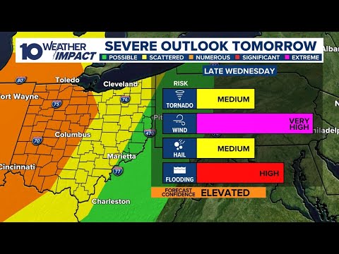
Tracking damaging winds, heavy rain expected Wednesday in central Ohio
Tracking damaging winds, heavy rain expected Wednesday in central Ohio
01:31:38 - Youtube video: IF9bOYqNzfk

LIVE RADAR: Tracking heavy rain, strong winds moving into central Ohio
LIVE RADAR: Tracking heavy rain, strong winds moving into central Ohio
07:21:59 - Youtube video: EJ_Hjp7RqIw
Columbus, Ohio weather forecast for June 16, 2025 | Cloudy with an isolated shower/storm possibl
Columbus, Ohio weather forecast for June 16, 2025 | Cloudy with an isolated shower/storm possibl
00:03:03 - Youtube video: 4fUAWjTPfJk

Columbus, Ohio weather forecast for April 16, 2025 | Sunshine and mild temps
Columbus, Ohio weather forecast for April 16, 2025 | Sunshine and mild temps
00:03:19 - Youtube video: 0N2vCQKz_ew