Loading...
Related Footage

Sunday 5 PM Tropical Update: PTC 6 forms in the southern Gulf, forecast to become hurricane
Sunday 5 PM Tropical Update: PTC 6 forms in the southern Gulf, forecast to become hurricane
00:05:41 - Youtube video: jNPKa0N2VgI
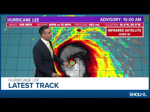
Tropical update: Hurricane Lee expected to become Cat. 5 storm
Tropical update: Hurricane Lee expected to become Cat. 5 storm
00:14:16 - Youtube video: 1u3do10S9qo

Tuesday Noon Tropical Update: TS Helene to become a hurricane
Tuesday Noon Tropical Update: TS Helene to become a hurricane
00:04:07 - Youtube video: XM6RBAsuNAQ
Friday 5 AM Tropical Update: Tropics remain busy, new area to watch in the Caribbean
Friday 5 AM Tropical Update: Tropics remain busy, new area to watch in the Caribbean
00:04:15 - Youtube video: D5-V_G3FFcI
Tuesday 5 AM Tropical Update: Development possible in Gulf of Mexico
Tuesday 5 AM Tropical Update: Development possible in Gulf of Mexico
00:03:24 - Youtube video: -T9azI9usSM
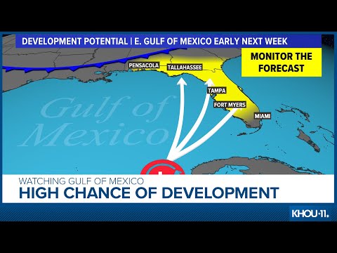
Friday 12 PM Tropical Update: Watching the Gulf of Mexico
Friday 12 PM Tropical Update: Watching the Gulf of Mexico
00:02:25 - Youtube video: Ojpr-1-L8KM
Tropical update: Will we soon have Idalia in the Gulf of Mexico?
Tropical update: Will we soon have Idalia in the Gulf of Mexico?
00:07:59 - Youtube video: QM1PcE4PFnc

Monday 4PM Tropical Update: Francine expected stronger at landfall, shifts west
Monday 4PM Tropical Update: Francine expected stronger at landfall, shifts west
00:07:40 - Youtube video: 9B8P2hwPC14