Loading...
Related Footage
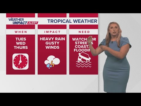
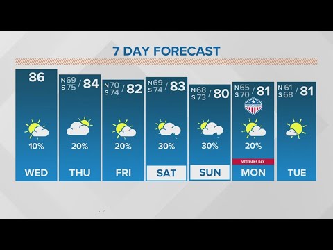
New Orleans Weather: Tropical system forms, expected to bring impacts to Gulf Coast
New Orleans Weather: Tropical system forms, expected to bring impacts to Gulf Coast
00:05:18 - Youtube video: Kzc2YugEn9Q
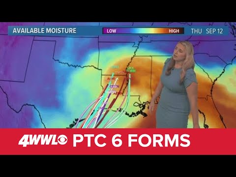
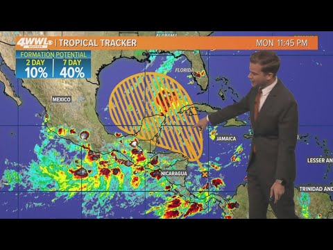
Sunday 5 PM Tropical Update: PTC 6 forms in the southern Gulf, forecast to become hurricane
Sunday 5 PM Tropical Update: PTC 6 forms in the southern Gulf, forecast to become hurricane
00:05:41 - Youtube video: jNPKa0N2VgI
Tuesday 5PM Weather Update: Calm weather in New Orleans as Hurricane Milton barrels towards Florida
Tuesday 5PM Weather Update: Calm weather in New Orleans as Hurricane Milton barrels towards Florida
00:04:25 - Youtube video: dWxVXh_AMzE
Wednesday 5PM Weather Update: What can New Orleans expect from Hurricane Helene? Here's latest
Wednesday 5PM Weather Update: What can New Orleans expect from Hurricane Helene? Here's latest
00:05:06 - Youtube video: _NkQPDp6ekw
New Orleans Weather: Warm temps set record, while Hurricane Rafael heads into Gulf
New Orleans Weather: Warm temps set record, while Hurricane Rafael heads into Gulf
00:03:41 - Youtube video: 9EIrW3CKH-A

Friday 5 AM Tropical Update: Tropics remain busy, new area to watch in the Caribbean
Friday 5 AM Tropical Update: Tropics remain busy, new area to watch in the Caribbean
00:04:15 - Youtube video: D5-V_G3FFcI
Tuesday 5 AM Tropical Update: Development possible in Gulf of Mexico
Tuesday 5 AM Tropical Update: Development possible in Gulf of Mexico
00:03:24 - Youtube video: -T9azI9usSM
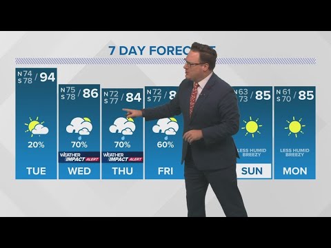
New Orleans Weather: Drier and hotter start; potentially impactful rain returns midweek
New Orleans Weather: Drier and hotter start; potentially impactful rain returns midweek
00:04:51 - Youtube video: OWAFSut9IjM