Loading...
Related Footage
13Weather Forecast | 4 p.m. update, Sept. 3, 2025
13Weather Forecast | 4 p.m. update, Sept. 3, 2025
00:02:31 - Youtube video: 2pm9Ly8jpDE
13Weather Forecast | 4:30 p.m. update, Sept. 17, 2025
13Weather Forecast | 4:30 p.m. update, Sept. 17, 2025
00:03:14 - Youtube video: BkKKnYogmh8
13Weather Forecast | 4 p.m. update, Sept. 17, 2025
13Weather Forecast | 4 p.m. update, Sept. 17, 2025
00:02:54 - Youtube video: sYjM66bYoRI
13Weather Forecast | 4 p.m. update, Sept. 10, 2025
13Weather Forecast | 4 p.m. update, Sept. 10, 2025
00:01:32 - Youtube video: YsnovGsfV3Y
13Weather Forecast | 4:30 p.m. update, Sept. 24, 2025
13Weather Forecast | 4:30 p.m. update, Sept. 24, 2025
00:01:50 - Youtube video: alkIY8tytZs
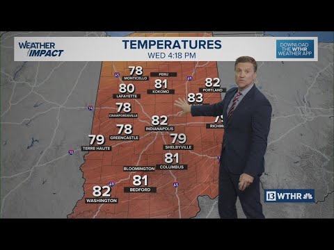
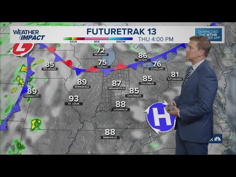
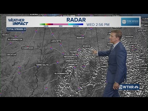
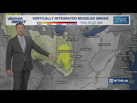
13Weather Forecast | 4 p.m. update, Sept. 24, 2025
13Weather Forecast | 4 p.m. update, Sept. 24, 2025
00:02:59 - Youtube video: 6vRZa41MB-A

Sean Ash recaps active April weather, looks ahead to May forecast | Outside the Forecast
Sean Ash recaps active April weather, looks ahead to May forecast | Outside the Forecast
00:08:18 - Youtube video: VxTsFXC7dc4
13Weather Forecast | 4:30 p.m. update, Sept. 3, 2025
13Weather Forecast | 4:30 p.m. update, Sept. 3, 2025
00:02:33 - Youtube video: maQwLyikHgs