Loading...
Related Footage

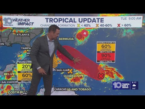
Tropical Weather Impact: Hurricane Erin to become Cat 3, two spots to watch in the tropics
Tropical Weather Impact: Hurricane Erin to become Cat 3, two spots to watch in the tropics
00:14:03 - Youtube video: 7Kw-MSm55FY

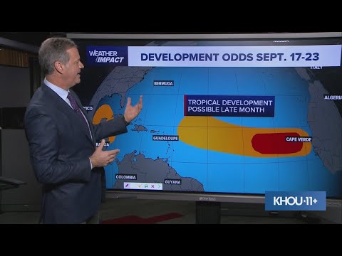
Tracking the Tropics: Tropical Depression Three forms in the central Atlantic
Tracking the Tropics: Tropical Depression Three forms in the central Atlantic
00:05:18 - Youtube video: 0gTZRThScAs

Hurricane Erin now in the Atlantic as Category 1 storm, the first of 2025
Hurricane Erin now in the Atlantic as Category 1 storm, the first of 2025
00:01:08 - Youtube video: TkbhXg-XzbQ
Tracking the Tropics: Hurricane Gabrielle, two other invests in the Atlantic
Tracking the Tropics: Hurricane Gabrielle, two other invests in the Atlantic
00:02:00 - Youtube video: lsTNlesQreg

Tracking the Tropics: Hurricane Idalia intensifies to 120 mph
Tracking the Tropics: Hurricane Idalia intensifies to 120 mph
00:00:14 - Youtube video: r5AqsDzSHoo
Tropics update: Quiet in the Atlantic for the peak of hurricane season
Tropics update: Quiet in the Atlantic for the peak of hurricane season
00:11:27 - Youtube video: jdhEWr3A08s

Tracking the Tropics: Bye-bye hurricane season!
Tracking the Tropics: Bye-bye hurricane season!
00:00:48 - Youtube video: 4mxDSlyNkXs

Tracking the Tropics: Tropical Storm Gabrielle expected to become hurricane Sunday
Tracking the Tropics: Tropical Storm Gabrielle expected to become hurricane Sunday
00:01:21 - Youtube video: umkUYlSSWnI