> Tracking storms, showers across Tampa Bay region
Tracking storms, showers across Tampa Bay region
Clip ID 2485340
3rd Party Rights
Add to
Share
Add to Review Link
By Request
By Request assets are not available for immediate purchase.
This content has not been pre-checked for copyright.
Per clip rates are for 20 seconds of final usage. If you are using more then 20 seconds or need a different file format or have questions about clearances contact us
Description
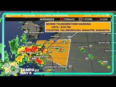
LIVE RADAR: We're keeping track of showers and storms across the Tampa Bay area.
After areas of heavy rainfall yesterday we will see more of the same today. Pockets of heavy showers and storms with tropical downpours will be likely this afternoon and evening. Clouds and rain chances will keep high temperatures slightly below average in the mid to upper 80s.
Another rounds of afternoon storms is likely Friday with highs in the 80s. We will need to watch for areas of localized flooding if storms move over some of the same areas day after day.
Rain chances will stick around as the Gulf low pressure dives south and then east this weekend. The National Hurricane Center currently gives this disturbance a 20% chance of developing into a tropical system. It really doesn't matter if it technically turns tropical because either way, it will primarily just be a rainmaker for Florida.
MORE: https://www.wtsp.com/article/weather/forecast/weather-forecast-wtsp/67-489786259
►Subscribe: https://on.wtsp.com/youtube
►Website: https://www.wtsp.com/
►Facebook: https://facebook.com/10TampaBay
►Twitter: https://twitter.com/10TampaBay