> LIVE RADAR: Tracking threat of strong storms in central Ohio Monday
LIVE RADAR: Tracking threat of strong storms in central Ohio Monday
Clip ID 2495139
3rd Party Rights
Add to
Share
Add to Review Link
By Request
By Request assets are not available for immediate purchase.
This content has not been pre-checked for copyright.
Per clip rates are for 20 seconds of final usage. If you are using more then 20 seconds or need a different file format or have questions about clearances contact us
Description
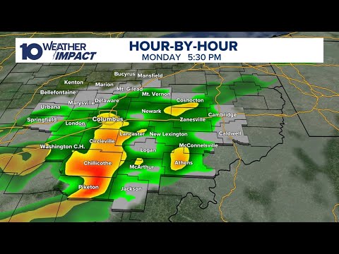
Scattered showers and storms are developing this afternoon and some of them may be strong to severe, especially across eastern Ohio. Hail and strong winds are the main concerns with the strongest storms. Further west, showers and storms will still be around, but the severe threat is lower.
LATEST FORECAST: https://www.10tv.com/weather
Rain and storm chances will linger into Tuesday as a slow-moving storm system continues to spin over the Ohio River Valley. A few storms could develop, mainly in the afternoon, and especially if there is any sunshine during the day. The strongest of these will likely occur this afternoon and early evening, Tuesday's biggest threat for persistent rain and heavy downpours at times.
Once the system finally exits the rea, the weather will start to improve! We'll get some drier and sunnier conditions from Wednesday through Mother's Day weekend, though we still cannot rule out rain 100% most days. The best chance for these lingering showers and some storms looks to move in Thursday, dropping temps back into the 60s.
Temperatures will return to the 70s with nice weather currently on tap for Mother's Day weekend!