By Request assets are not available for immediate purchase.
This content has not been pre-checked for copyright.
Per clip rates are for 20 seconds of final usage. If you are using more then 20 seconds or need a different file format or have questions about clearances contact us
Description
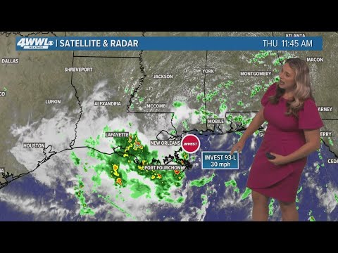
We’re live with a 3 p.m. weather cut-in for July 17, 2025, as southeast Louisiana remains under a Flood Watch.
A tropical disturbance in the Gulf, Invest 93, continues to bring waves of heavy rain across the region.
⚠️ Current threats:
A Flood Watch is in effect through late Friday night
Rainfall totals could reach 2–4 inches, with some areas over 6 inches
Storms may produce 2–4 inches of rain per hour, especially during peak heating
Breezy at times with urban flooding possible
🌊 About Invest 93:
Located just east of Louisiana, Invest 93 has a low chance of further tropical development
Due to its proximity to land, it's unlikely to strengthen—but still poses a significant rain and flood threat
🌡️ Today’s outlook:
80% chance of storms
Passing downpours with breaks
High: 87°
Stay with WWL for radar updates, street-level alerts, and continued impact coverage.
📲 Turn on WWL app alerts for flood safety info: https://www.wwltv.com/connect
📺 Stream full forecasts and cut-ins on WWL+: https://www.wwltv.com/watch
🌐 Follow WWLTV.com for ongoing coverage: https://www.wwltv.com/
#WWLWeather #Invest93 #FloodWatch #LiveRadar #LouisianaStorms