Loading...
Related Footage

National Hurricane Center Director explains the weather impacts to expect at landfall
National Hurricane Center Director explains the weather impacts to expect at landfall
00:04:27 - Youtube video: k5wZSrnCoiE

Sunday 5 PM Tropical Update: PTC 6 forms in the southern Gulf, forecast to become hurricane
Sunday 5 PM Tropical Update: PTC 6 forms in the southern Gulf, forecast to become hurricane
00:05:41 - Youtube video: jNPKa0N2VgI
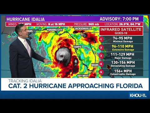
Tropical update: Hurricane Idalia intensifies as it edges closer to Florida
Tropical update: Hurricane Idalia intensifies as it edges closer to Florida
00:13:59 - Youtube video: cAtY4G4gbWA
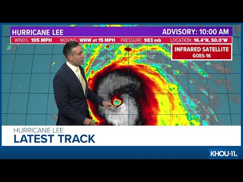
Tropical update: Hurricane Lee expected to become Cat. 5 storm
Tropical update: Hurricane Lee expected to become Cat. 5 storm
00:14:16 - Youtube video: 1u3do10S9qo

Hurricane Beryl upgrades to Category 5 storm
Hurricane Beryl upgrades to Category 5 storm
00:00:56 - Youtube video: NId4OdbD3Ek

Tuesday Noon Tropical Update: TS Helene to become a hurricane
Tuesday Noon Tropical Update: TS Helene to become a hurricane
00:04:07 - Youtube video: XM6RBAsuNAQ
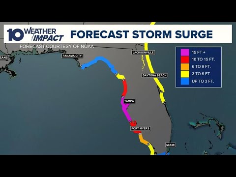
What does a storm surge mean? Potential impacts from Hurricane Milton
What does a storm surge mean? Potential impacts from Hurricane Milton
00:01:13 - Youtube video: qElXCcHsFFc

Tropical Weather Impact: TS Erin growing into hurricane, tracking Invest 98
Tropical Weather Impact: TS Erin growing into hurricane, tracking Invest 98
00:11:27 - Youtube video: VvLCmYC6fgk